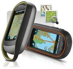
MAGELLAN eXplorist710 WATERPROOF HIKING GPS
$100
Posted almost 4 years ago in Fremont, CA
Condition: Used (normal wear)
Listed in categories: Sports & Outdoors - Camping & Hiking
SOLD
Additional images
Description
"I bought this eXplorist GPS for $400. Used it for SURFING & FISHING......"! PRODUCT DESCRIPTION "EXPLORIST 710 FEATURES" *3.2 Mega-Pixel Camera with Auto Focus Take photographs along your journey and reference the location where each photograph was taken afterward. Use the Integrated Microphone and Speaker to Record voice memos and playback in the field! All multimedia content can be geo-tagged with coordinates or attached to waypoints. "WORLD EDITION PRE-LOADED MAP" *The World Edition includes a detailed road network, water features, urban and rural land use, and a realistic shaded relief background. "SUMMIT SERIES USA PRE-LOADED MAP" *Summit Series USA is highly detailed topographic map based on 1:24,000 scale source maps. The map includes contour lines, land use areas, trails, waterways, and points of interest. Locate the nearest trailhead. Search nearest bike shops, fuel stations, or potable water source. Navigate safely in 3D perspective view while knowing the boundaries between private and public lands. "THREE-INCH TOUCH SCREEN" *An intuitive touch screen user interface and sunlight readable screen makes the eXplorist easy-to-use in almost any environment. "ONLINE EXPERIENCE SHARING" *The eXplorist GPS receiver supports GPX file format and connects seamlessly to a PC as an external drive. Simply save files to and from the device and share with your favorite online communities. "3-AXIS ELECTRONIC COMPASS & BAROMETRIC ALTIMETER" *Always know exactly where you are going, which direction is north, and your accurate altitude about sea level with built-in sensors. Know the direction to the geocache while standing still. Measure barometric pressure over time to track changing weather conditions. Use a number of different digital compass to always understand your cardinal directions. "PAPERLESS GEOCACHING" AND MUCH MUCH MORE............
Save, Report, and Share
Map is approximate to keep seller’s location private.
Related searches
- Fishing
- Surfboard
- Backpack
- Basketball hoops
- Fishing rod
- Cooler
- Snowmobile
- Fishing reels
- Baseball glove
- Baseball bats
- Duffle bag
- Sleeping bag
- Patriots jersey
- Curl bar
- Tennis rackets
- Speed bag
- Hiking backpack
- Treadmill nordictrack
- Softball glove