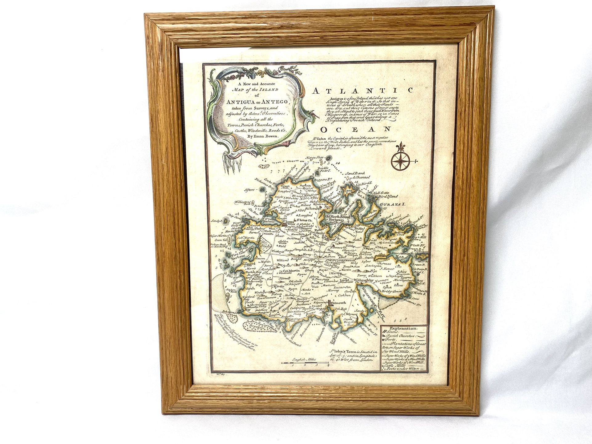
Antigua and Antego map By Eman Bowen/Vintage/Rare. An accurate map of the island of Antigua or Antego, taken from surveys, and adjusted by astronl.
$40
Posted almost 4 years ago in Johnstown, PA
Condition: Open Box (never used)
Listed in categories: Collectibles & Art - Antiques - Maps, Atlases, & Globes
Chat securely on the app

Sold by
Additional images
Details
Century
17th century
Description
Antigua and Antego map By Eman Bowen/Vintage/Rare. An accurate map of the island of Antigua or Antego, taken from surveys, and adjusted by astronl. observations. Containing all the towns, parish churches, forts, castles, windmills, roads &c. By Eman. Bowen. (London: Printed for William Innys, Richard Ware, Aaron Ward, J. and P. Knapton, John Clarke, T. Longman and T. Shewell, Thomas Osborne, Henry Whitridge ... M.DCC.XLVII) Author: Bowen, Emanuel Date: 1747 Short Title: Antigua or Antego. Publisher: London: William Innys [et al.] Type: Atlas Map Object Height cm: 32 Object Width cm: 23 Scale 1: 130,000 Note: Engraved map. Shows shoals, rocks under water, sugar works, cattle mills, etc. Has geographical notes and ornamental cartouche. Relief shown pictorially; depths by soundings. Reference: cf. LC Maps and charts of North America and the West Indies 1(contact info removed), 1999 (1752 ed.); P-Maps, p. 115 (1752 ed.); NMM p.356; M&B p 166. Country: Antigua and Barbuda Full Title: A new and accurate map of the island of Antigua or Antego, taken from surveys, and adjusted by astronl. observations. Containing all the towns, parish churches, forts, castles, windmills, roads &c. By Eman. Bowen. (London: Printed for William Innys, Richard Ware, Aaron Ward, J. and P. Knapton, John Clarke, T. Longman and T. Shewell, Thomas Osborne, Henry Whitridge ... M.DCC.XLVII) List No: 3733.066 Page No: No. 67 Series No: 69 Published In: A complete system of geography. Being a description of all the countries, islands, cities, chief towns, harbours, lakes, and rivers, mountains, mines, &c. of the known world ... In two volumes. The whole illustrated with seventy maps, by Emanuel Bowen, Geographer to His Majesty, being all new-drawn and ingraved according to the latest discoveries and surveys; making, of themselves, a complete atlas, for the sse of gentlemen, merchants, mariners, and others, who delight in history and geography ... Vol. 1. London: Printed for William Innys, Richard Ware, Aaron Ward, J. and P. Knapton, John Clarke, T. Longman and T. Shewell, Thomas Osborne, Henry Whitridge ... M.DCC.XLVII. Publication Author: Bowen, Emanuel Publication Date: 1747
Take action
Item location map
Map is approximate to keep seller’s location private.
Related searches
- Antique dresser
- Antique furniture
- Antique desk
- Antique table
- Antique mirror
- Antique clocks
- Antique chairs
- Antique cabinets
- Antique bottles
- Antique armoire
- Antique lamps
- Antique dolls
- Antique china
- Antique glass
- Vintage lamp
- Vintage pyrex
- Candelabra