Framed Peter Schenk the Elder 1645-1715 World Map On Foil
$69
Posted about 9 years ago in Ansonia, CT
Condition: Reconditioned/Certified
Listed in categories: Electronics & Media - Books, Movies, & Music
Chat securely on the app

Sold by
SOLD
Additional images
Description
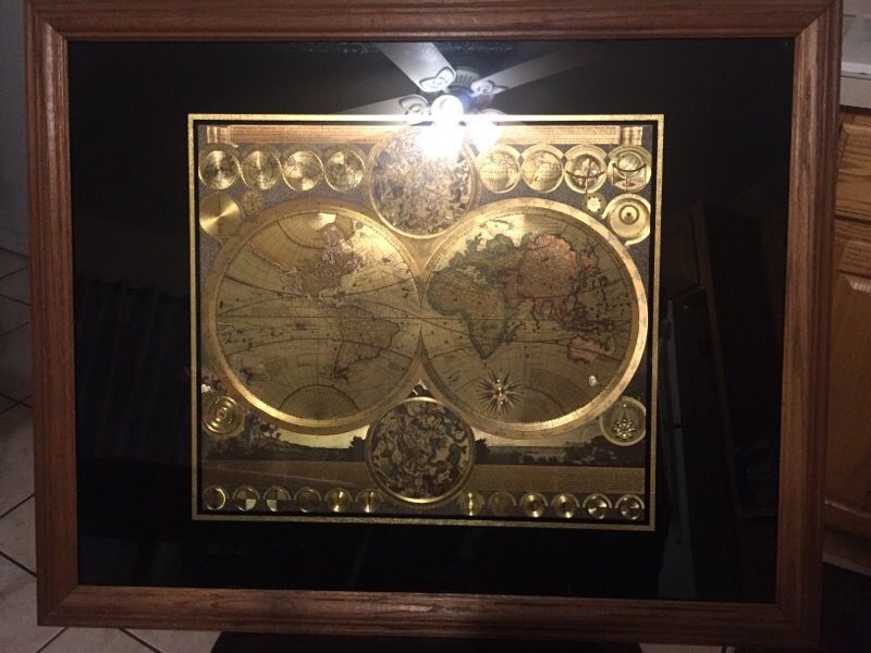
Vintage Rare 24K Gold Foil World Map AFTER Adam Freidrich Zurner & Peter Schenk the Elder, Stunning detail impressive depth due to unique engraving technique, Exquisitely complimented with quality glass hardwood frame. Vintage reproduction Map AFTER Adam Freidrich Zurner, who produced relatively few maps, but this tour-de-force incorporates interesting cartography - California as an island, Australia appearing almost as a rectangle and Japan sprouting a bulging Terra Iedso. There are detailed texts, projections of the planets and a number celestial diagrams. Vignettes below the map record numerous natural phenomena. A strong impression. Region: World Maps Mapmakers of the original map: Adam Friedrich Zurner Pieter Schenk Place and date of publication of the original : Amsterdam c.1700 Title: Planisphaerium Terrestre cum utroque Coelesti Hemisphaerio, sive Diversa Orbis Terraquei A fine example of a distinctive and uncommon double hemisphere map, elegantly and carefully engraved with a wealth of detail, embellished with more than 20 decorative scenes and scientific projections of the Celestial skies and contemporary astronomical theories and teachings. An attractive and interesting map full of detail including most of the coast of Australia, the western coast of New Zealand, and the routes and discoveries of exploreres Magellan, Dampier ("Nova Britannia" in 1700), Tasman, Gaetani and Chaumont. Surrounding the map is an elaborate border showing winds and climates, and along the bottom edge a panorama illustrating tempests, earthquakes, tides, vortices, and a textual commentary on all the natural phenomena illustrated. California is shown as an island, but very tentatively so, with etchings suggesting that it may be a peninsula, due early knowledge of Fra. Eusebio Kino's observations from California. It's in excellent vintage condition with the only flaw being some minor normal wear to the wood frame (surface wear and a few minor imperfections are...
Take action
Item location map
Map is approximate to keep seller’s location private.
Related searches
- Apple watch
- Bluetooth speaker
- Drone
- Beats
- Apple tvs
- Fitbit
- Headphones
- Wireless headphones
- Bluetooth headphones
- Beats wireless
- Chromecast
- Microsoft surface
- Beats solo
- Beats headphones
- Hoverboards
- iPads
- Firestick
- Earbuds
- Wireless earbuds